Introduction
The NBM Oceanic data is interesting in that it presents probabalistic wind information. This probability information is derived from the range of outcomes present in the many different forecast models that are blended into this model.
The list of model inputs, for version 3.0 of NBM, is:
- NAM (North American Mesoscale Forecast System - 12km)
- NAMNest (NAM 3km high resolution nest)
- GFS (Global Forecast System)
- GEFS (Global Ensemble Forecast System)
- GDPS (CMC - Environment Canada Global Deterministic – PoP12/QPF06 only)
- GEPS (CMCE - Environment Canada Global Ensemble)
- EKDMOS (Ensemble Kernel Density Model Output Statistics)
- Gridded GFS MOS (GMOS or MOSGuide)
- HRRR (High Resolution Rapid Refresh), CONUS only
- RAP (Rapid Refresh). (Also RAP Alaska)
- Gridded LAMP (GLMP Localized Aviation MOS Product), CONUS only
- HiResWindow ARW NCEP (High-Resolution Window Forecast System (HIRESW))
- HiResWindow NMMB NCEP (High-Resolution Window Forecast System (HIRESW))
- SREF (Short Range Ensemble Forecast) CONUS, Alaska, Puerto Rico sectors
- NAVGEME (Navy FNMOC Global Ensemble)
The update to NBM, version 3.1, has added the following model inputs:
- ECMWFD (European Centre for Medium-Range Weather Forecasts, deterministic - 0.25 degree)(CONUS, OCONUS) (0000, 1200 UTC runs)
- ECMWFE (European Centre for Medium-Range Weather Forecasts, Ensemble - 1.0 degree)(CONUS, OCONUS) (0000, 1200 UTC runs)
- NAVGEMD (Navy FNMOC Global deterministic - 0.50 degree For most elements, 1.0 degree for significant wave heights)(CONUS, OCONUS, and Oceanic domain) (0000, 0600, 1200, 1800 UTC runs)
- GDPS (CMCD Environment Canada Global deterministic model (25km) for weather elements other than PoP12/QPF06)
- RDPS (Canadian Regional deterministic model - 10km) (CONUS and Alaska) (0000, 0600, 1200, 1800 UTC runs)
- REPS (Canadian Regional ensemble model - 15km) (CONUS) (0000 and 1200 UTC runs) (Precipitation products only)
- HRRR Alaska (High Resolution Rapid Refresh - 3km) (a). 1-18 hours (0300, 0900, 1500, 2100 UTC runs) (b). 1-36 hours (0000, 0600, 1200, 1800 UTC runs)
- HiResWindow ARW Mem2 (3-km High-Resolution Window Forecast System (configured like NSSL WRF) (CONUS and OCONUS)
- WW3 (0.5 degree WaveWatchIII global deterministic model)
- WW3 (0.5 degree WaveWatchIII global ensemble model)
- WW3 (0.16 and 0.06 degree WaveWatchIII high resolution regional models) (CONUS and OCONUS)
- GLW (2.5km Great Lakes Wave model)
The v3.2 update to NBM has added the following model inputs:
- ACCESS-G (The Australian global model)
- GFS-FV3 visibility
- additional improvements for other weather elements (temperature, rain, …)
The v4.0 update to NBM has added the following model inputs:
- GFS-MOS (0000-, 0600-, 1200-, and 1800-UTC cycles)
- Deterministic ECMWF-MOS (0000- and 1200-UTC cycles)
- Ensemble ECMWF-MOS (0000- and 1200-UTC cycles)
- EKDMOS (0600- and 1800-UTC cycles)
- NAM-MOS (0000- and 1200-UTC cycles)
- LAMP (hourly)
Wind speed and direction
The NBM Oceanic model processes wind speed and direction differently.
Firstly, consider wind direction. The wind direction at each point is broken into 10 degree bins. For example, the first wind bin covers the range 355° to 5°, the second bin covers the range 5° to 15°, and so on. To find the wind direction at a point, all of the model inputs are considered for that point. For each model, the forecast wind direction is found, and then the appropriate direction bin is incremented. After all of the model inputs have been considered, the most populated bin is used as the result - this is the wind direction that the majority of the models agreed upon.
Wind strength in this model is handled differently, and there are five values provided with different probabilities assigned to them.
Consider this example. This is for a point just south of the big island of Hawaii, at a time when there is a possible storm/hurricane arriving in three or four days. This data is for a point 96H into the forecast centered in a strong wind area of the possible storm.
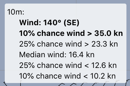
The wind direction is the direction agreed to by the majority of the models, within +/- 5 degrees. As for the speed, the spread of values within the models is showing that:
- 10% of the values are < 10.2 knots
- 25% of the values are < 12.6 knots
- 50% of the values are < 16.4 knots
- 75% of the values are < 23.3 knots (or 25% > 23.3)
- 90% of the values are < 35.0 knots (or 10% > 35.0)
Clearly, there is much more information here than what most weather models provide, which is generally wind speed and gust values.
It may take a little while for you to become familiar with how to interpret all of this information. This data is expressing great uncertainty on what is going to be happening at this point in the forecast. The ability of this model to express uncertainty makes it unique among the weather forecast models available.
Note that the upper wind speed is 35 knots. This is not saying that there is a 10% chance that the wind speed will be 35 knots, but rather that there is a 10% chance that the wind speed will be greater than 35 knots.
A meteogram view of this data is also very useful. This is the meteogram view for the point in the above example:
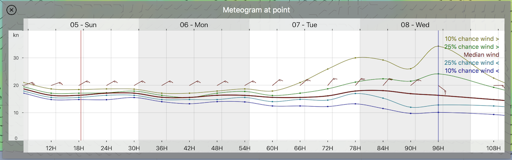
Note that in the meteogram view that there is close agreement among all of the models for the earlier hours in the forecast. The first two days of wind is showing beautiful trade wind conditions, and all models agree within around five knots (this isn’t exactly right, as NBM oceanic does not establish the true upper or lower values that may be present, only the 10% upper/lower probability wind, a subtle distinction.) If you were making plans at this point for the first two days, you could be pretty certain on what to expect.
Midway through day three and into day 4 the uncertainty grows and grows, with the spread of possible wind speeds growing wildly.
Also note, that while not shown, the meteogram view is showing that all of the models start to agree on the conditions again at around day 6 through the remainder of the forecast (back to beautiful tradewinds.)
There is a lot of information here, and it may take a little time for all of us to become familiar with interpreting it.
Conclusion
The NBM Oceanic model blends many different forecast models into its result, and presents a range of possible outcomes at each point. Examining these probability values allows you to infer how closely all of the models agree on the outcome. This model is unique in being able to express the certainty of its forecast. If all of the model inputs agree on the forecast at a point, then the range of probable wind speeds for that point will be narrow. As the range of outcomes widens at a point, the degree of confidence you should have on what may happen at that point should decrease.
The ability of the NBM Oceanic model to express certainty in its forecast is unique and potentially makes this model one of the best sources for wind information for sailors, and others interested in wind forecasts.
This is a new resource for the weather community to consider.
Feedack is welcome on how useful you find this model.